Xinjiang Geography
Xinjiang Province Geography: Xinjiang's topography characterizes with three broadly parallel mountain ranges with two basins lying between them. The Tianshn Mountains runs in the middle of the province and divides Xinjiang into north and south. North across the Junggar Basin is Mountain Altay and across the Tarim Basin to the south are Kunlun Mountains. China's largest desert, Taklimakan Desert is in the south while the second largest one, Gurbantunggut Desert is in the north. Major rivers are Tarim River, Ili River and Ertix River.
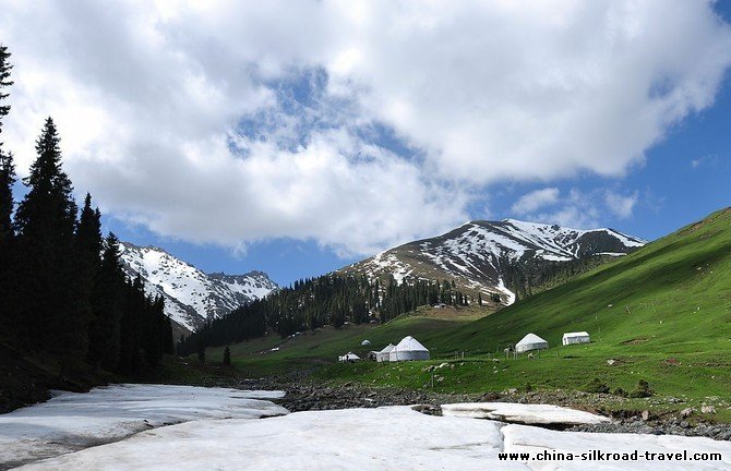
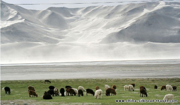
Tianshan Mountains is one of the largest in Asia, and in the ancient records, it was recorded as “the North Mountain”’ “the Snow Mountain” and “Yin Mountain”. And in the Tang Times, it was recorded as “Zheloman Mountains.” Tianshan Mountains started from the Pamirs with two branches. One branch lies in Central Asia in the north-west direction, and the another branch lies through the mid Xinjiang to the east. And this branch, about 1700kilometers long, divides the Xinjiang land into two parts: South Xinjiang and North Xinjiang. In Xinjiang, Tianshan Mountain are a symbol of the vast region.
The huge Tianshan Mountains consist of three parallel ranges. The northern part is of Alatao Mountain, Bolokenu Mountain and Yilianhabirga Mountain. And the middle part is of Wusun Mountain, Nalat mountain and Erbin Mountain. The southern part of Kekshale Mountain, Harktawu Mountain, Kekhtiek Mountain, and the eastern part is of Bogda Mountain, Balkun Mountain and Karlik Mountain. The highest peak of Tianshan Mountain is Tomur peak, 7435meters above the sea level. In the mountain there are many basins and valleys with pretty landscape, of which Yili Valley, Yuldos Basin, Turfan Basin, Zhaosu Basin, Baicheng Basin and Hami Basin are well know.
Tianshan Mountains is magnificent in scenery and rich in natural resource. And spruce trees are seen everywhere in the mountain areas. Also Tianshan Mountain has the largest area of glaciers in China, the area of glaciers takes 16% of the total in the country. The glaciers, like huge “solid” reservoirs, melt together with snow in summer time, and the water fills the valleys, and it flows into Yili River, Aksu River, Manas River and Urumqi River. And the water nourishes the basins and oases in North and South Xinjiang. And in the mountains, there is a plenty of mineral reserves and forestry resources, about 400700hectares in area
Altai Mountain: “Altai”, a Mongolian name, means “gold”. So it is the name of Altai Mountains, “the gold mountains”. Altai Mountains, about 2000kilometers in length, northwest to southeast in direction, lies in Inner Asia, covering the land of China, Russia and Mongolia. The middle part of the mountains lies in the borders between China, Russia and Mongolia, about 500 kilometers long. And the southern slope area is in the territory of Xinjiang. The general height of this part is about 3000 meters and the highest peak, the Friendship peak, lies in the border between China, Russia and Mongolia, 4374 meters above sea level. In the northern part, the highest peak, Altun Aoboo Peak, is about 3290 meters in height. The average rail fall in the mountain area is about 400-800mm. and the forests of dahurian larch mainly in the area of the altitude between 1200 meters -2300meters, and below the forests, is fine pastures. There is a visible change of summer temperature from higher mountain to lower hills. In winter there is thick snow in he mid part of the mountain areas. In the mountains there are some small basins. Seven natural landscape belts can be seen in Altai Mountains and they form a vertical natural vegetation belts. In the eastern part of Altai Mountains is Keketohai, which is a well known for nonferrous metal reserve and smeltery. In the western part is Kanas Lake area, a famous tourist site and a natural reserve as well. The rivers of Altai Mountain flow from the north to the south, belonging to two river system, one is Erqis River system, starting from Habahe to Funyun, and the down part: Ebe River, flows into the Arctic Ocean. So Erqis River System us only of the Arctic Water System. Another one, Urunkor River System, formed in Qinghe County area with many small rivers, flows into Urunkor Lake, and the river is an inland one of Zhungar Basin. Altai Mountains is rich in mineral reserves, such as gold, nonferrous metals and rate stones. The nonferrous metal reserves and rare stones in the eastern part have been exploited
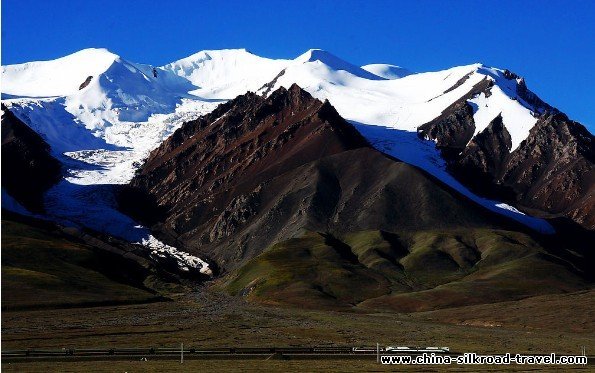
Kunlun Mountains In the ancient Chinese book “Shuijingzhu”’ Kunlun Mountains was recorded as “Aruda Mountain”. Kunlun Mountains, 2500 kilometers long and 150-350kilometers wide, is from the Parmirs in the west, lies along the borderline between Xinjiang and Tibet and extends into Qinghai and Sichuan. The part of the mountains in the area of Xinjiang is about 1700kilometers in length. The average height of the mountains ridges is about 5000meters and it is lower in the eastern part than in the western part. In the western part of Kunlun Mountains west to Pishan County, there are 3 peaks 7000 meters high above the sea-level. The part between Pishan County and Qiemo County, called the mid part, is 500meters lower than that of the western part with 8 peaks 6000meters high above the sea level. East to Qiemo County area lies the Eastern Kunlun Mountains, the average height of the mountain ridges is 500meters lower than that of the mid part with 4 peaks 6000meters high above the sea level. From the middle part of the mountains, flow out Hotan River, Keria River and Niya River.
Kunlun Mountains area is considered as one of the most dry mountain areas in Asia, with scarce vegetation and very few human activites. However, in the area 5000meters above the sea level, there exist large glaciers, which bring life to the mountain area. And the mountains is rich in mineral resources and more than 10 high peaks 6000-7000meters above the sea level in the mountain ranges attract mountaineers and tourists from other parts of China and abroad.
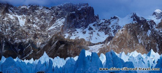
Karakunlun Mountains, south to the western part of Kunlun Mountains and west to Wakhan Corridor, linking Hindukush Mountains, ending at the Kongka Pass between India and China, lies from northwest to southeast. The northern slope area is in the territory of China. It is about 500kilometers long and 150 kilometers wide. The general height of the mountain ridges is about 5500 meters. And Karakunlun Mountains has 15 high peaks with the altitude of 7500meters above the sea level, of which 4 are over 8000meters above the sea level. Qiaoger (K2), the second highest peak in the world, stands at the border between China and Pakistan. There is much rainfall in the area of the southwest slope, the annual amount of rainfall is 800mm—2400mm in the high mountain area and the snowline is in the area of around 5000meters above the sea level, and this area is the largest mountain glacier area in the low and mid latitude areas of the world. And the tops of the mountains here, in the shape of mountain highland, are capped with the ice-snow with six large glacier, 50-70 kilometers along respectively. In the northern slope of Karakunlun Mountains there is less rainfall and the snow line is higher than that in the southern slope, around 5400meters. The Yinsuget Glacier in the northwest slope of the Qiaoger Peak, 42 kilometers in Length, is the longest in china,and the of the glaciers is at the Kurqin Valley, which is the eastern source of Yarkend River. The Mingtiegai Pass was an important passage on the ancient Silk Road, not far from the pass is Kunjerab pass, by which the Karakoram Highway passes. And in the eastern part of the mountains there was a traditional merchant route between India and China. As it is a high and cold area, agriculture is impossible in the mountain area but there are rich mineral and hydraulic resources.
The pamirs, the eastern part of which is located in the extreme southwest Xinjiang, is where Tianshan mountain ranges and Kunlun mountain ranges converge and the general altitude is between 3200-4500 meters. The Pamirs consists of magnificent rolling mountains hills and it is called the father of all the mountains. In the ancient Chinese literature, there are some records of the Pamirs. In the “Life of Emperor Mu”, it is said that the Pamris was called Chong mountain, meaning “the only highest mountain on the Earth”. In the “the Western Regions of Hanshu”, a book written by Ban Gu, the Pamirs was called Congling. In the book written by Xuanzang, the famous monk of the Tang times who went on a pilgrimage for Buddhist scriptures to ancient India, the Pamirs was named as “ Bomlio”. And in the Book “Xintangshu” (New history of Tang Dynasty), the Pamirs was named as “Bomi”. In the history, the Pamirs was an important strategic juncture on the ancient Silk Road, and the dynasty of China in different times established their administrative and military posts on the Pamirs. And the Pamirs was vividly described in their great books by Faxian, a monk and Buddhism tourist of the Jing Dynasty, Xuanzang and Mac Polo, who travelled through the Pamirs. In the eastern Mountain area of the Pamirs, there exists a huge area of glacier, 2200 square kilometers in all and 635 square kilometers only in the Gongger-Muztagh peaks, where the glaciers are as thick as 100meters and when one looks at them, one would find the whole peaks are capped by the ice. Some of the glaciers here, such as Kekehili Glacier in the eastern slope, Jiangbulak Glacier in the northwestern slope of Muztagh Peak, the Karaya-kara Glacier in the northern slope of Gongger Peak, are 20 kilometers long, and the landscape here is magnificent and astonishing. There are 3 peaks on the Pamirs that are open to the mountaineers: the Gonngger Peak(7719 meters above sea level), the Gongger Jiubie Peak(7595meters) and Muztagh-ata(7509meters and it is called “the father of Ice Mountains). Every year, they attract thousand of mountaineers and tourists from all over the world.
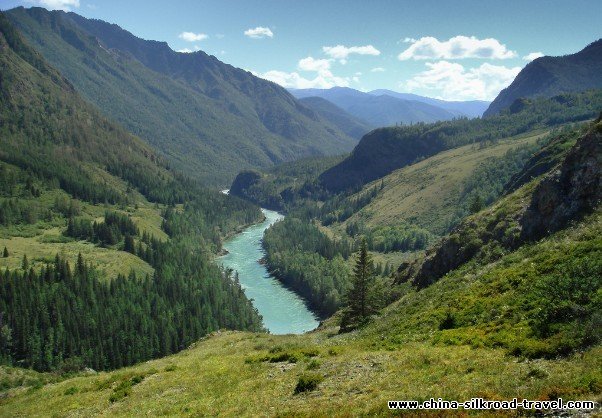
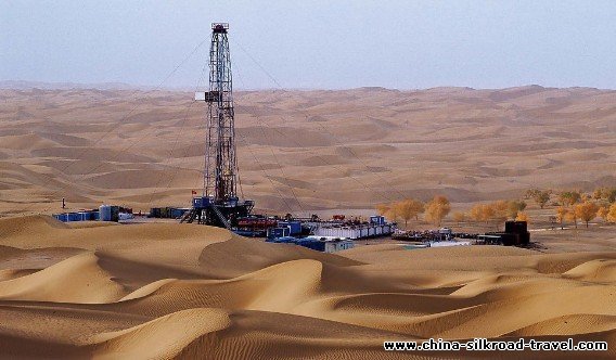
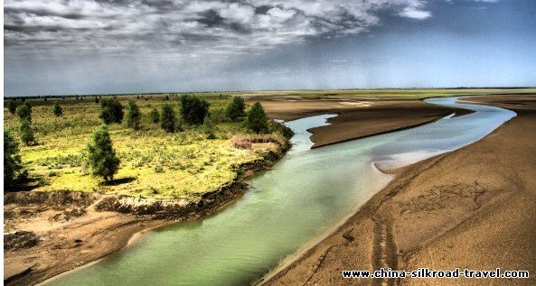
Tarim Basin, 1400kilometers long and 550 kilometers wide, 560000square kilometers in area, lies between Tianshan Mountains, Kunlun Mountains and Altun Mountains and it is the largest basin in China. According to the scientists, the Basin was formed in the land shift during the late Sinian Period, so it has rich ancient geographic and climatic information in it and great amount of reserves of oil, natural gas, coal, uranian, salt, lead and zin. The central area of the Basin is Taklamakhan Desert, the second largest in the world and the largest in China. The Desert is 1000 kilometers from the western edge to the eastern edge and 400kilometers from the northern to the southern. It is very dry with endless sand dunes but with very little vegetation. So it is called the “Sea of the Death”. However, the huge mountain ranges circling the Basin provide it with water for life, and there are many oases with rivers and lakes around the Basin, such as Kashgar Oasis, Yarkent Oasis, Aksu Oasis, which are important in grain and cotton production of Xinjiang. Tarim River, the longest inland river in China, flow within the Basin and when in its prime, the river was 2100 kilometers long, almost flew through the whole Basin. In the ancient times, many “town states” dependent on the natural resources provided by the oasis, rivers and lakes were established in the Tarim Basin, and the southern and middle routes of the ancient Silk Road went along the Basin, thus the regional ancient civilizations were developed. Due to the changes in the nature and human world, many of the “town-states” were buried by the sand. Since the 19th century, Tarim Basin has been a hot area for explores who came here to look for the ancient sites of the civilization and to recover the ancient civilizations.
Tarim River, which was called Shushui or Conglinghe in the ancient Chinese records, flows in the northern part of Tarim Basin. It was about 1000 kilometers in its prime, and the length of the river would be 2179 kilometers f the length of its major branch. Yarkent River, is put into account. So it is the longest inland river of China and the drainage area is about 198,000 square kilometers. In the long past, most of the rivers of Tarim Basin flew into Tarim River, which made great contribution to the formation of the civilization of ancient Xinjiang. And it is because of this that Tarim River has been called “mother river” of the region. In the past years, due to the development of local industry and agriculture, which in turn has brought about changes in the nature and human society, the river ends at Daxihazi Reservoir near to Tielkhelik with the water only from three branches, Aksu River starting from Tianshan Mountain, Yarkent River and Hotan River starting from Kunlun Mountains and the water is less and less from the upper parts to the downs parts. The river’s alluvial valley is very large with fertile soil and luxurious vegetation, so it is suitable for the developing farming. And the river itself often changed its sheds and ran wild, so the river valley is like the maze. The central government has paid great attention to eco-environmental changes of Tarim River, including the cutout of the river water and many measures, including leading the water to the down valley and restoring the vegetation of the bank area, have been taken to improve the environment.